In this post, I compare the nautical (navigational) charts from the following iOS mobile apps: Navionics Boating app, Garmin ActiveCaptain (using BlueChart g2 charts), 0100100 Merellä and Nautics Sailmate. In addition to those, I have also included oeSENC (vector chart) from o-charts.org and photos of the official TRAFICOM paper charts.
The app screenshots are full screen screenshots from an iPad. The computer screenshots (OpenCPN with oeSENC charts) are taken with the same zoom level (the same chart area visible on the same screen area). Larger images can be found on a separate page which only has the images and can be expanded to any width.
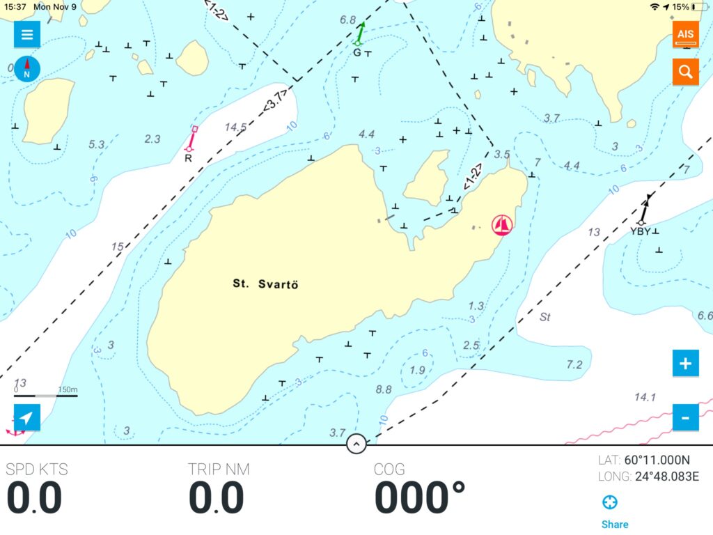
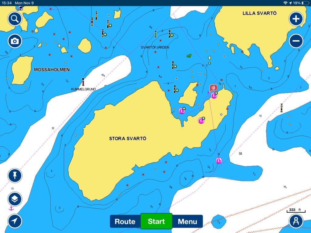
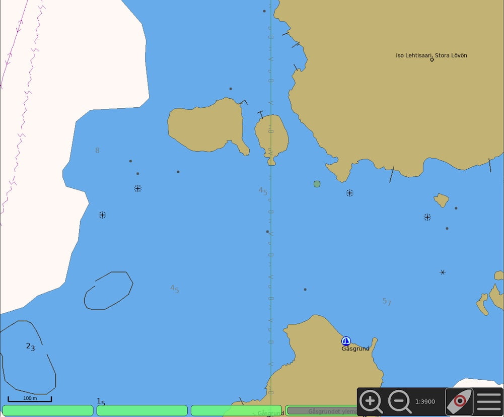
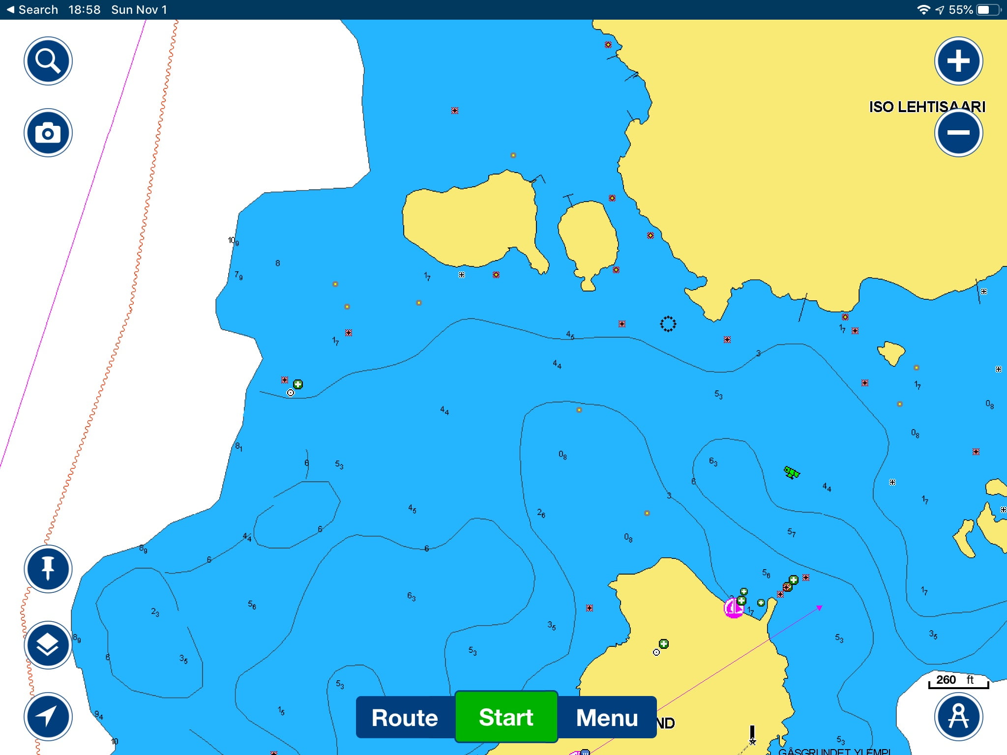
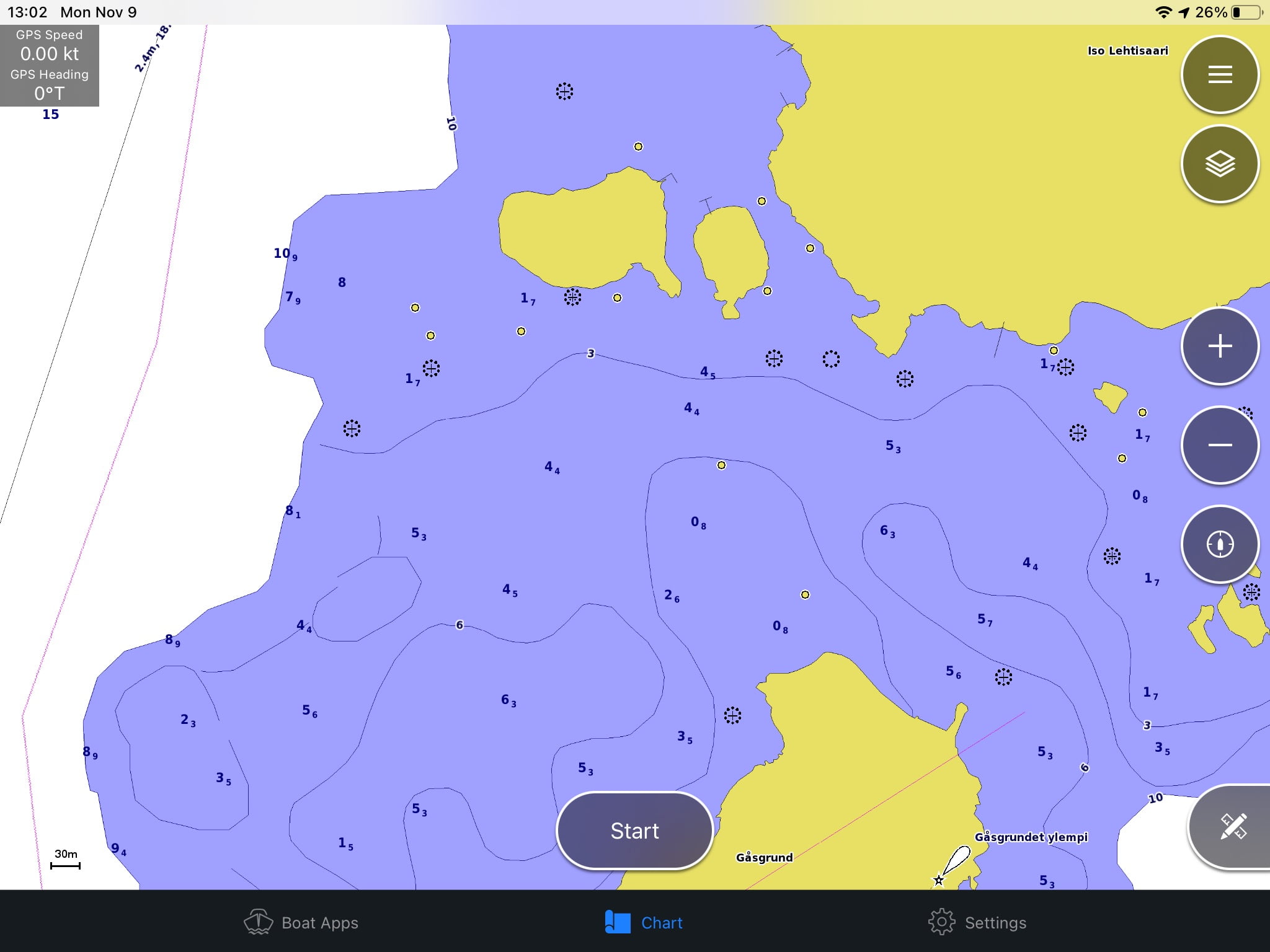
Below is a coastal area in Finland shown on different apps and charts.

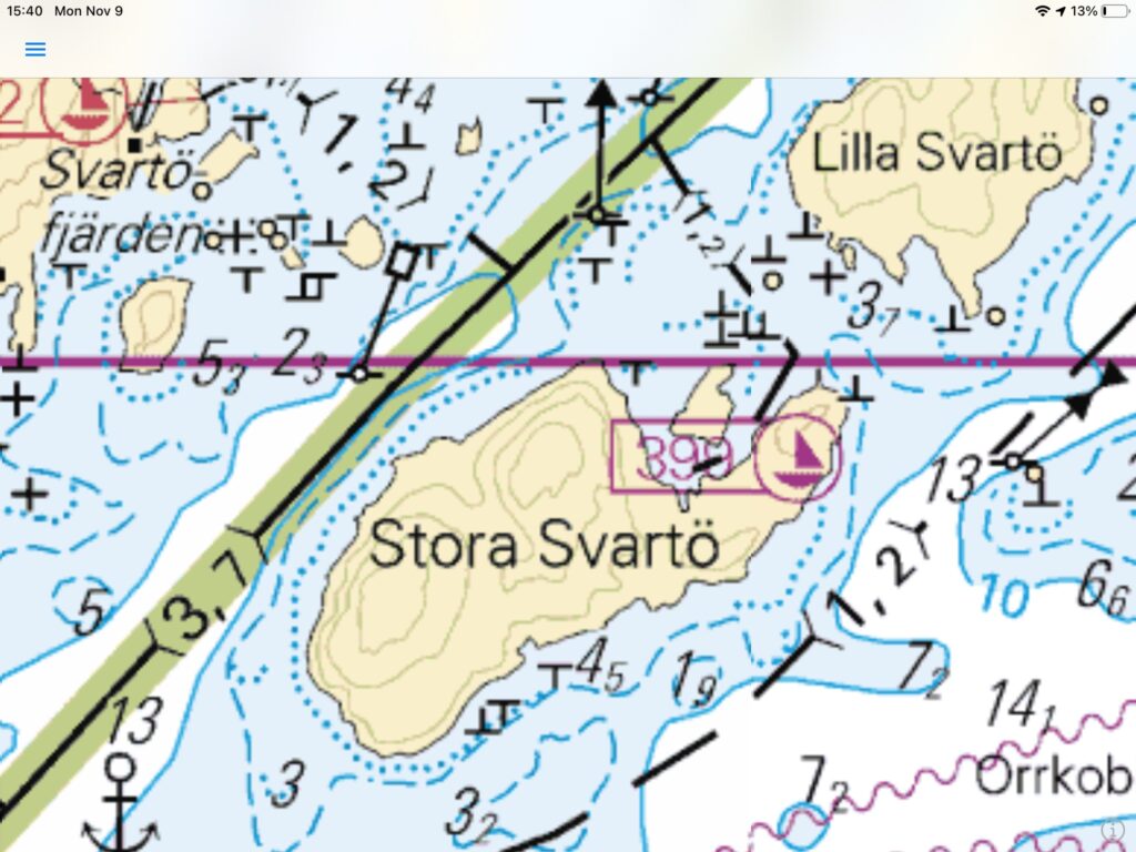
Official paper chart %22%20transform%3D%22matrix(4%200%200%204%202%202)%22%20fill-opacity%3D%22.5%22%3E%3Cellipse%20fill%3D%22%23adadad%22%20rx%3D%221%22%20ry%3D%221%22%20transform%3D%22matrix(-106.03993%20-9.03016%202.27937%20-26.76628%2090.1%2067.7)%22%2F%3E%3Cellipse%20fill%3D%22%23bababa%22%20cx%3D%22134%22%20cy%3D%2260%22%20rx%3D%2237%22%20ry%3D%2228%22%2F%3E%3Cellipse%20fill%3D%22%23e6e6e6%22%20cx%3D%22133%22%20cy%3D%22191%22%20rx%3D%22101%22%20ry%3D%22101%22%2F%3E%3Cellipse%20fill%3D%22%23b8b8b8%22%20cx%3D%2276%22%20cy%3D%2285%22%20rx%3D%2232%22%20ry%3D%2223%22%2F%3E%3Cellipse%20fill%3D%22%23e8e8e8%22%20cx%3D%2263%22%20cy%3D%2228%22%20rx%3D%2260%22%20ry%3D%2217%22%2F%3E%3Cellipse%20fill%3D%22%23e7e7e7%22%20rx%3D%221%22%20ry%3D%221%22%20transform%3D%22matrix(-36.45712%2010.17901%20-49.87754%20-178.64128%20223.4%2040.8)%22%2F%3E%3Cpath%20fill%3D%22%23b8b8b8%22%20d%3D%22M135.7%2085.2l69.8-9.4L225.8%2056l-62.7%2057.7z%22%2F%3E%3Cellipse%20fill%3D%22%23e6e6e6%22%20cx%3D%224%22%20cy%3D%22137%22%20rx%3D%2262%22%20ry%3D%2262%22%2F%3E%3Cellipse%20fill%3D%22%23e4e4e4%22%20cx%3D%22129%22%20cy%3D%226%22%20rx%3D%22179%22%20ry%3D%2224%22%2F%3E%3Cellipse%20fill%3D%22%23bcbcbc%22%20rx%3D%221%22%20ry%3D%221%22%20transform%3D%22matrix(-20.00124%20-12.32661%2011.07173%20-17.96506%208.8%2057.9)%22%2F%3E%3C%2Fg%3E%3C%2Fsvg%3E)
Sailmate %27%20fill-opacity%3D%27.5%27%3E%3Cellipse%20fill%3D%22%23b2a488%22%20fill-opacity%3D%22.5%22%20rx%3D%221%22%20ry%3D%221%22%20transform%3D%22matrix(-267.39388%2065.1836%20-40.06992%20-164.37342%20374.4%20421.6)%22%2F%3E%3Cellipse%20fill%3D%22%239adaff%22%20fill-opacity%3D%22.5%22%20rx%3D%221%22%20ry%3D%221%22%20transform%3D%22rotate(-103.4%20601.2%20-217.2)%20scale(153.24278%20251.27228)%22%2F%3E%3Cellipse%20fill%3D%22%2359a8eb%22%20fill-opacity%3D%22.5%22%20rx%3D%221%22%20ry%3D%221%22%20transform%3D%22matrix(-8.43772%20-136.43831%20443.70077%20-27.43968%20232.3%20122.7)%22%2F%3E%3Cpath%20fill%3D%22%23d9b9ac%22%20fill-opacity%3D%22.5%22%20d%3D%22M968.3%20770.3l-388.6-89.7L646.6%20391l388.6%2089.7z%22%2F%3E%3Cellipse%20fill%3D%22%23c1dcef%22%20fill-opacity%3D%22.5%22%20rx%3D%221%22%20ry%3D%221%22%20transform%3D%22matrix(177.07301%20-161.68988%2078.25435%2085.69945%20157%20385.7)%22%2F%3E%3Cellipse%20fill%3D%22%23ad9582%22%20fill-opacity%3D%22.5%22%20rx%3D%221%22%20ry%3D%221%22%20transform%3D%22matrix(14.36039%20-151.91702%20206.11485%2019.48359%20809.4%201.9)%22%2F%3E%3Cpath%20fill%3D%22%2359ba8e%22%20fill-opacity%3D%22.5%22%20d%3D%22M310.9%20725.3l308.9-258-524%20148.5z%22%2F%3E%3Cellipse%20fill%3D%22%235ba6db%22%20fill-opacity%3D%22.5%22%20rx%3D%221%22%20ry%3D%221%22%20transform%3D%22matrix(-5.45045%2095.6256%20-180.17207%20-10.26941%20648%20218.1)%22%2F%3E%3Cellipse%20fill%3D%22%238c8a89%22%20fill-opacity%3D%22.5%22%20rx%3D%221%22%20ry%3D%221%22%20transform%3D%22matrix(12.87083%20-92.6709%20174.60273%2024.25015%20903.3%20662.8)%22%2F%3E%3Cellipse%20fill%3D%22%237ac7ff%22%20fill-opacity%3D%22.5%22%20rx%3D%221%22%20ry%3D%221%22%20transform%3D%22rotate(-36.1%20589.3%20188.5)%20scale(289.21056%2075.90027)%22%2F%3E%3C%2Fg%3E%3C%2Fsvg%3E)
Official vector chart (oeSENC) %22%20transform%3D%22matrix(4%200%200%204%202%202)%22%20fill-opacity%3D%22.5%22%3E%3Cellipse%20fill%3D%22%238cf9d5%22%20cx%3D%2269%22%20cy%3D%2218%22%20rx%3D%22112%22%20ry%3D%2229%22%2F%3E%3Cellipse%20fill%3D%22%23fff%22%20rx%3D%221%22%20ry%3D%221%22%20transform%3D%22rotate(-173.5%2060.6%2049.7)%20scale(133.27674%2046.75842)%22%2F%3E%3Cellipse%20fill%3D%22%23fff%22%20rx%3D%221%22%20ry%3D%221%22%20transform%3D%22rotate(-133.5%20129%2037.5)%20scale(166.05961%2030.54785)%22%2F%3E%3Cellipse%20fill%3D%22%23dacfd4%22%20rx%3D%221%22%20ry%3D%221%22%20transform%3D%22matrix(13.84621%2026.97397%20-50.61128%2025.97965%20104.3%20167.5)%22%2F%3E%3Cellipse%20fill%3D%22%23c9d9d5%22%20cx%3D%22209%22%20cy%3D%2250%22%20rx%3D%2281%22%20ry%3D%2228%22%2F%3E%3Cpath%20fill%3D%22%239dfde2%22%20d%3D%22M-19.5%2057.6l53-35.8%2018%2026.6-53%2035.8z%22%2F%3E%3Cellipse%20fill%3D%22%23dde56d%22%20rx%3D%221%22%20ry%3D%221%22%20transform%3D%22matrix(-.77119%20-9.55812%2033.96501%20-2.74044%20243.9%20.6)%22%2F%3E%3Cellipse%20fill%3D%22%23dcd0d6%22%20cx%3D%2216%22%20cy%3D%22164%22%20rx%3D%2249%22%20ry%3D%2233%22%2F%3E%3Cellipse%20fill%3D%22%23fff%22%20rx%3D%221%22%20ry%3D%221%22%20transform%3D%22matrix(-10.94818%20-25.04095%2055.57373%20-24.29745%2051%2078.2)%22%2F%3E%3Cpath%20fill%3D%22%23ffffa6%22%20d%3D%22M108%20102l-36%206%2045-40z%22%2F%3E%3C%2Fg%3E%3C%2Fsvg%3E)
0100100 %22%20transform%3D%22matrix(4%200%200%204%202%202)%22%20fill-opacity%3D%22.5%22%3E%3Cellipse%20fill%3D%22%23fffffa%22%20cx%3D%22228%22%20cy%3D%22178%22%20rx%3D%2263%22%20ry%3D%2263%22%2F%3E%3Cellipse%20fill%3D%22%23009fde%22%20rx%3D%221%22%20ry%3D%221%22%20transform%3D%22matrix(79.36687%2020.8215%20-9.1905%2035.03212%2098.5%2021.4)%22%2F%3E%3Cellipse%20fill%3D%22%23f5d456%22%20rx%3D%221%22%20ry%3D%221%22%20transform%3D%22matrix(-8.69593%20-22.65367%2039.21301%20-15.05246%20104.4%20108.2)%22%2F%3E%3Cellipse%20fill%3D%22%2311abd9%22%20rx%3D%221%22%20ry%3D%221%22%20transform%3D%22rotate(-80.8%20151%2049.8)%20scale(36.56432%2065.61865)%22%2F%3E%3Cellipse%20fill%3D%22%2380a263%22%20cx%3D%22213%22%20rx%3D%2245%22%20ry%3D%2245%22%2F%3E%3Cellipse%20fill%3D%22%2320b4db%22%20rx%3D%221%22%20ry%3D%221%22%20transform%3D%22matrix(-152.76049%2097.6944%20-15.60738%20-24.40458%20.2%2069)%22%2F%3E%3Cellipse%20fill%3D%22%23a2deff%22%20rx%3D%221%22%20ry%3D%221%22%20transform%3D%22matrix(60.13784%20-43.32444%2017.11124%2023.7518%20201.1%20115.7)%22%2F%3E%3Cellipse%20fill%3D%22%23a6d6ff%22%20rx%3D%221%22%20ry%3D%221%22%20transform%3D%22matrix(-17.82443%20-13.50605%2048.91953%20-64.5609%2025.6%20124.2)%22%2F%3E%3Cellipse%20fill%3D%22%23ffe0d9%22%20rx%3D%221%22%20ry%3D%221%22%20transform%3D%22matrix(-15.44778%20-43.31185%2062.95028%20-22.4521%20228.2%20185.5)%22%2F%3E%3Cellipse%20fill%3D%22%234dc5e3%22%20rx%3D%221%22%20ry%3D%221%22%20transform%3D%22matrix(135.9439%2025.81649%20-3.2107%2016.9068%20160.4%2053.7)%22%2F%3E%3C%2Fg%3E%3C%2Fsvg%3E)
Navionics Boating %22%20transform%3D%22matrix(4%200%200%204%202%202)%22%20fill-opacity%3D%22.5%22%3E%3Cellipse%20fill%3D%22%2369676f%22%20cx%3D%2281%22%20cy%3D%22191%22%20rx%3D%22182%22%20ry%3D%2235%22%2F%3E%3Cpath%20fill%3D%22%23c5b5ff%22%20d%3D%22M183%207L-16%20158%2030-16z%22%2F%3E%3Cellipse%20fill%3D%22%23cae058%22%20rx%3D%221%22%20ry%3D%221%22%20transform%3D%22matrix(43.79984%20-23.38694%2013.71655%2025.68882%20101.9%20115.1)%22%2F%3E%3Cellipse%20fill%3D%22%23d8cdff%22%20rx%3D%221%22%20ry%3D%221%22%20transform%3D%22matrix(35.12322%2047.72648%20-31.90154%2023.47721%20210.9%2097.4)%22%2F%3E%3Cellipse%20fill%3D%22%23cce358%22%20rx%3D%221%22%20ry%3D%221%22%20transform%3D%22matrix(6.151%2027.97636%20-44.13675%209.7041%20225%20.2)%22%2F%3E%3Cellipse%20fill%3D%22%23b2a4ff%22%20rx%3D%221%22%20ry%3D%221%22%20transform%3D%22matrix(7.00794%20-22.92194%2082.83536%2025.32531%20108.4%2033.9)%22%2F%3E%3Cellipse%20fill%3D%22%238980bb%22%20rx%3D%221%22%20ry%3D%221%22%20transform%3D%22rotate(-39%2030.4%20-22.5)%20scale(37.55684%2030.7083)%22%2F%3E%3Cpath%20fill%3D%22%237f7c8e%22%20d%3D%22M25.4%20152.3L140.5%20138l6.1%2049.6L31.5%20202z%22%2F%3E%3Cellipse%20fill%3D%22%23b2a2ff%22%20cx%3D%22237%22%20cy%3D%2285%22%20rx%3D%2251%22%20ry%3D%2234%22%2F%3E%3Cellipse%20fill%3D%22%23d0c4ff%22%20cy%3D%2296%22%20rx%3D%2235%22%20ry%3D%2250%22%2F%3E%3C%2Fg%3E%3C%2Fsvg%3E)
Garmin ActiveCaptain


Middle: Official vector chart (oeSENC) and 0100100
Bottom: Navionics Boating and Garmin ActiveCaptain
Navionics and Garmin has pretty much the same level of basic detail as the source for them is the same (Garmin owns Navionics). However, the user generated content differs. For example in the screenshots above, Navionics has some (user added) seamarks that are not shown on Garmin. Sailmate basically shows the raster version of the official marine chart. 0100100 has their own distinctive simplified design.
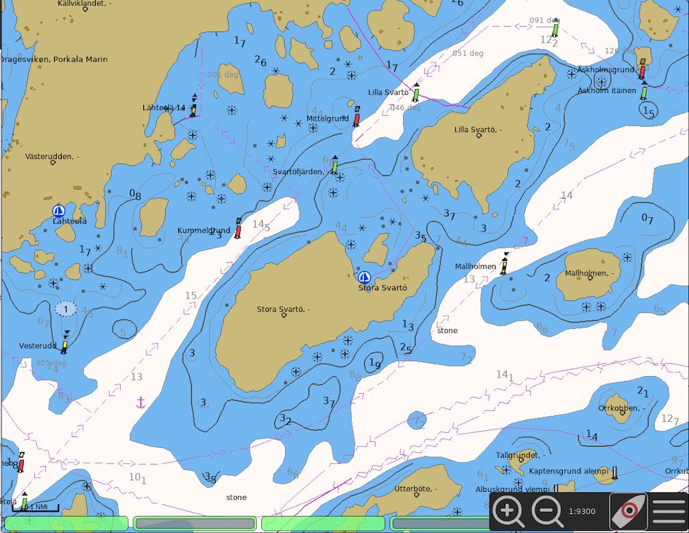
Below is a zoomed out view from the same area. As you can see, 0100100.fi loses all the rocks when zoomed out. This is probably done to declutter the view, but it is also very dangerous.
%22%20transform%3D%22matrix(4%200%200%204%202%202)%22%20fill-opacity%3D%22.5%22%3E%3Cpath%20fill%3D%22%23987b56%22%20d%3D%22M-19.5-7.6L52.6%204%2023.5%20187.6-48.6%20176z%22%2F%3E%3Cellipse%20fill%3D%22%23f0f2f6%22%20rx%3D%221%22%20ry%3D%221%22%20transform%3D%22matrix(44.3283%20-90.08702%2066.58317%2032.76298%20166.3%20103.1)%22%2F%3E%3Cellipse%20fill%3D%22%23dfa551%22%20rx%3D%221%22%20ry%3D%221%22%20transform%3D%22matrix(-21.0398%20-24.90157%2045.52769%20-38.46719%2020.2%2017.2)%22%2F%3E%3Cellipse%20fill%3D%22%23b5bab6%22%20cx%3D%2256%22%20cy%3D%22123%22%20rx%3D%2230%22%20ry%3D%22158%22%2F%3E%3Cellipse%20fill%3D%22%238d9bae%22%20rx%3D%221%22%20ry%3D%221%22%20transform%3D%22matrix(-9.67802%2070.42761%20-21.22327%20-2.91646%2010.3%20133.7)%22%2F%3E%3Cellipse%20fill%3D%22%23e6e6e8%22%20cx%3D%22146%22%20cy%3D%2216%22%20rx%3D%2237%22%20ry%3D%2259%22%2F%3E%3Cellipse%20fill%3D%22%23e6e6e8%22%20cx%3D%22255%22%20cy%3D%2289%22%20rx%3D%2252%22%20ry%3D%2252%22%2F%3E%3Cellipse%20fill%3D%22%23b3b5b8%22%20rx%3D%221%22%20ry%3D%221%22%20transform%3D%22matrix(18.35882%2027.20743%20-39.95589%2026.96113%20236.9%20177.8)%22%2F%3E%3Cellipse%20fill%3D%22%23b5b6ba%22%20rx%3D%221%22%20ry%3D%221%22%20transform%3D%22rotate(175%2044.5%2019.4)%20scale(21.41277%2044.69701)%22%2F%3E%3Cellipse%20fill%3D%22%23b2b4b7%22%20rx%3D%221%22%20ry%3D%221%22%20transform%3D%22matrix(-11.3191%2012.01747%20-28.186%20-26.548%20228.4%209)%22%2F%3E%3C%2Fg%3E%3C%2Fsvg%3E)
Official paper chart %22%20transform%3D%22matrix(4%200%200%204%202%202)%22%20fill-opacity%3D%22.5%22%3E%3Cellipse%20fill%3D%22%23aaa%22%20rx%3D%221%22%20ry%3D%221%22%20transform%3D%22matrix(-2.7964%2023.10825%20-57.27362%20-6.93087%2087%2071.7)%22%2F%3E%3Cellipse%20fill%3D%22%23a9a9a9%22%20rx%3D%221%22%20ry%3D%221%22%20transform%3D%22matrix(-42.9296%207.64693%20-3.41143%20-19.15165%20220.6%20181)%22%2F%3E%3Cellipse%20fill%3D%22%23a8a8a8%22%20rx%3D%221%22%20ry%3D%221%22%20transform%3D%22matrix(3.23397%2034.09502%20-36.05271%203.41966%200%20183)%22%2F%3E%3Cellipse%20fill%3D%22%23e6e6e6%22%20cx%3D%22140%22%20cy%3D%2222%22%20rx%3D%22255%22%20ry%3D%2230%22%2F%3E%3Cellipse%20fill%3D%22%23e6e6e6%22%20cx%3D%22104%22%20cy%3D%22168%22%20rx%3D%2271%22%20ry%3D%2271%22%2F%3E%3Cellipse%20fill%3D%22%23e6e6e6%22%20rx%3D%221%22%20ry%3D%221%22%20transform%3D%22matrix(88.7272%201.81609%20-1.122%2054.81663%20224.3%20107.1)%22%2F%3E%3Cpath%20fill%3D%22%23b3b3b3%22%20d%3D%22M143%2045l-58%208%2063%2020z%22%2F%3E%3Cellipse%20fill%3D%22%23e4e4e4%22%20rx%3D%221%22%20ry%3D%221%22%20transform%3D%22matrix(-23.83144%2026.60512%20-49.90002%20-44.69776%2022.2%20108)%22%2F%3E%3Cpath%20fill%3D%22%23b9b9b9%22%20d%3D%22M28%2048h24v24H28z%22%2F%3E%3Cellipse%20fill%3D%22%23bfbfbf%22%20rx%3D%221%22%20ry%3D%221%22%20transform%3D%22matrix(10.49701%2022.13405%20-30.78324%2014.59887%20110.6%2074.8)%22%2F%3E%3C%2Fg%3E%3C%2Fsvg%3E)
Sailmate %27%20fill-opacity%3D%27.5%27%3E%3Cellipse%20fill%3D%22%238f9866%22%20fill-opacity%3D%22.5%22%20rx%3D%221%22%20ry%3D%221%22%20transform%3D%22matrix(123.70936%20109.06447%20-207.1742%20234.993%20117.4%20134.3)%22%2F%3E%3Cellipse%20fill%3D%22%23735b5a%22%20fill-opacity%3D%22.5%22%20rx%3D%221%22%20ry%3D%221%22%20transform%3D%22matrix(262.1283%2037.30732%20-14.95213%20105.05652%20882.5%20769.6)%22%2F%3E%3Cellipse%20fill%3D%22%2367bdf6%22%20fill-opacity%3D%22.5%22%20rx%3D%221%22%20ry%3D%221%22%20transform%3D%22matrix(64.29864%2083.01583%20-400.73881%20310.38612%20175.4%20377.6)%22%2F%3E%3Cellipse%20fill%3D%22%23cfd0cb%22%20fill-opacity%3D%22.5%22%20rx%3D%221%22%20ry%3D%221%22%20transform%3D%22rotate(-107%20446.4%20128.5)%20scale(206.65256%20633.26576)%22%2F%3E%3Cellipse%20fill%3D%22%2384daff%22%20fill-opacity%3D%22.5%22%20rx%3D%221%22%20ry%3D%221%22%20transform%3D%22rotate(-8.5%201443.7%20-6295.8)%20scale(85.03167%20231.83128)%22%2F%3E%3Cellipse%20fill%3D%22%235dabc7%22%20fill-opacity%3D%22.5%22%20rx%3D%221%22%20ry%3D%221%22%20transform%3D%22rotate(-36.7%20494%20-571.6)%20scale(131.4472%20207.01485)%22%2F%3E%3Cellipse%20fill%3D%22%2374e0ca%22%20fill-opacity%3D%22.5%22%20rx%3D%221%22%20ry%3D%221%22%20transform%3D%22matrix(161.39428%2080.11682%20-30.9611%2062.37074%20324.4%20590.4)%22%2F%3E%3Cellipse%20fill%3D%22%23cbccc3%22%20fill-opacity%3D%22.5%22%20rx%3D%221%22%20ry%3D%221%22%20transform%3D%22matrix(172.50554%20-16.00286%2021.49051%20231.66066%20684.1%2073.7)%22%2F%3E%3Cellipse%20fill%3D%22%2397d6ff%22%20fill-opacity%3D%22.5%22%20rx%3D%221%22%20ry%3D%221%22%20transform%3D%22matrix(33.97431%2078.8098%20-143.80842%2061.99473%20146.7%20466.7)%22%2F%3E%3Cellipse%20fill%3D%22%23babf54%22%20fill-opacity%3D%22.5%22%20rx%3D%221%22%20ry%3D%221%22%20transform%3D%22matrix(-82.05207%20-88.77416%20151.83813%20-140.34075%2021.8%2068.5)%22%2F%3E%3C%2Fg%3E%3C%2Fsvg%3E)
Official vector chart (oeSENC) %22%20transform%3D%22matrix(4%200%200%204%202%202)%22%20fill-opacity%3D%22.5%22%3E%3Cellipse%20fill%3D%22%238cf6d1%22%20rx%3D%221%22%20ry%3D%221%22%20transform%3D%22matrix(-10.82263%2035.39922%20-32.61442%20-9.97123%20107.7%2028.3)%22%2F%3E%3Cellipse%20fill%3D%22%23fff%22%20rx%3D%221%22%20ry%3D%221%22%20transform%3D%22matrix(111.43413%20-47.76073%2019.55275%2045.61999%20138.2%20110)%22%2F%3E%3Cellipse%20fill%3D%22%23cbd8d5%22%20rx%3D%221%22%20ry%3D%221%22%20transform%3D%22rotate(-51.6%2068.9%2029.3)%20scale(138.48856%2039.91625)%22%2F%3E%3Cellipse%20fill%3D%22%23d6d0d2%22%20cx%3D%22244%22%20cy%3D%22135%22%20rx%3D%2243%22%20ry%3D%2240%22%2F%3E%3Cellipse%20fill%3D%22%23d7d1d3%22%20rx%3D%221%22%20ry%3D%221%22%20transform%3D%22matrix(-4.28872%20-53.06743%2030.793%20-2.48858%207.3%20163)%22%2F%3E%3Cellipse%20fill%3D%22%23d6d0d2%22%20cx%3D%22234%22%20cy%3D%2217%22%20rx%3D%2235%22%20ry%3D%2234%22%2F%3E%3Cellipse%20fill%3D%22%23fff%22%20cx%3D%2277%22%20cy%3D%22118%22%20rx%3D%2254%22%20ry%3D%2254%22%2F%3E%3Cpath%20fill%3D%22%23cfd5d3%22%20d%3D%22M120%2071l21-69%2047%2060z%22%2F%3E%3Cellipse%20fill%3D%22%23a6fff2%22%20rx%3D%221%22%20ry%3D%221%22%20transform%3D%22matrix(34.85035%20-10.52194%204.24518%2014.06073%2012.4%2092.7)%22%2F%3E%3Cellipse%20fill%3D%22%23d6d1d3%22%20rx%3D%221%22%20ry%3D%221%22%20transform%3D%22matrix(16.80558%20-17.5247%2022.81553%2021.8793%20141.2%20175)%22%2F%3E%3C%2Fg%3E%3C%2Fsvg%3E)
0100100 %22%20transform%3D%22matrix(4%200%200%204%202%202)%22%20fill-opacity%3D%22.5%22%3E%3Cellipse%20fill%3D%22%23e4c13b%22%20rx%3D%221%22%20ry%3D%221%22%20transform%3D%22matrix(-33.1493%2042.43393%20-27.61848%20-21.5755%2012.7%2022.8)%22%2F%3E%3Cellipse%20fill%3D%22%234ba7c4%22%20rx%3D%221%22%20ry%3D%221%22%20transform%3D%22rotate(25.6%20-3.4%20236.7)%20scale(53.12534%2060.62141)%22%2F%3E%3Cellipse%20fill%3D%22%23a0d6ff%22%20rx%3D%221%22%20ry%3D%221%22%20transform%3D%22rotate(167.5%20109.1%2066.2)%20scale(78.39661%2064.74437)%22%2F%3E%3Cellipse%20fill%3D%22%239fd4ff%22%20rx%3D%221%22%20ry%3D%221%22%20transform%3D%22matrix(36.15322%20-75.79681%2047.78569%2022.7926%2035%20190.4)%22%2F%3E%3Cellipse%20fill%3D%22%239ee8ab%22%20rx%3D%221%22%20ry%3D%221%22%20transform%3D%22matrix(-46.74587%20-3.41233%202.06087%20-28.23208%20115.3%20110.4)%22%2F%3E%3Cpath%20fill%3D%22%234ea6bb%22%20d%3D%22M106%20165h123v27H106z%22%2F%3E%3Cellipse%20fill%3D%22%2314bdd9%22%20rx%3D%221%22%20ry%3D%221%22%20transform%3D%22rotate(163.1%20-4.3%2055.9)%20scale(38.19856%2014.91354)%22%2F%3E%3Cellipse%20fill%3D%22%239ae3a5%22%20rx%3D%221%22%20ry%3D%221%22%20transform%3D%22rotate(-18.4%20208.7%20-525.1)%20scale(28.36747%2036.6371)%22%2F%3E%3Cpath%20fill%3D%22%2382c08d%22%20d%3D%22M89.4-4.2L40%2088.5%2020.6%2078.2%2070-14.5z%22%2F%3E%3Cellipse%20fill%3D%22%2327d0e3%22%20cx%3D%22102%22%20cy%3D%2243%22%20rx%3D%2224%22%20ry%3D%2224%22%2F%3E%3C%2Fg%3E%3C%2Fsvg%3E)
Navionics Boating %22%20transform%3D%22matrix(4%200%200%204%202%202)%22%20fill-opacity%3D%22.5%22%3E%3Cellipse%20fill%3D%22%23626167%22%20rx%3D%221%22%20ry%3D%221%22%20transform%3D%22rotate(2%20-5288%204782)%20scale(238.75992%2031.24526)%22%2F%3E%3Cellipse%20fill%3D%22%23cae24e%22%20rx%3D%221%22%20ry%3D%221%22%20transform%3D%22rotate(123.7%204%2015.9)%20scale(48.75658%2029.57161)%22%2F%3E%3Cpath%20fill%3D%22%23e6deff%22%20d%3D%22M271%20148l-133-16%2030-54z%22%2F%3E%3Cpath%20fill%3D%22%23cabcff%22%20d%3D%22M-16%20124l93-86%205%20123z%22%2F%3E%3Cellipse%20fill%3D%22%23cab8ff%22%20cx%3D%22254%22%20cy%3D%2225%22%20rx%3D%2244%22%20ry%3D%2244%22%2F%3E%3Cellipse%20fill%3D%22%23baf%22%20rx%3D%221%22%20ry%3D%221%22%20transform%3D%22matrix(-26.87486%20-11.02218%2015.15496%20-36.9516%20104.3%2031)%22%2F%3E%3Cellipse%20fill%3D%22%238e7bf2%22%20rx%3D%221%22%20ry%3D%221%22%20transform%3D%22rotate(-64.1%20234%20-83)%20scale(39.88365%2021.93898)%22%2F%3E%3Cellipse%20fill%3D%22%23cbcdc2%22%20rx%3D%221%22%20ry%3D%221%22%20transform%3D%22matrix(55.3447%2074.2506%20-24.84136%2018.51618%20185.1%2048.5)%22%2F%3E%3Cellipse%20fill%3D%22%23c9ccb9%22%20cx%3D%22104%22%20cy%3D%22104%22%20rx%3D%2244%22%20ry%3D%2244%22%2F%3E%3Cellipse%20fill%3D%22%23c2b4ff%22%20rx%3D%221%22%20ry%3D%221%22%20transform%3D%22matrix(-7.52194%20-28.46941%2038.14696%20-10.07886%2022.9%20113.6)%22%2F%3E%3C%2Fg%3E%3C%2Fsvg%3E)
Garmin ActiveCaptain


Middle: Official vector chart (oeSENC) and 0100100
Bottom: Navionics Boating and Garmin ActiveCaptain
There are areas in official charts that have much less detail than charts from, for example, Navionics or Garmin. See below a comparison. As you can see, the official charts are missing a lot depth information as well as some rocks.
%22%20transform%3D%22translate(.7%20.7)%20scale(1.46875)%22%20fill-opacity%3D%22.5%22%3E%3Cellipse%20fill%3D%22%23ca8e33%22%20rx%3D%221%22%20ry%3D%221%22%20transform%3D%22matrix(1.2961%20-36.49901%2086.58455%203.07467%20206.2%2024.3)%22%2F%3E%3Cellipse%20fill%3D%22%23d6e0ea%22%20rx%3D%221%22%20ry%3D%221%22%20transform%3D%22matrix(-80.7093%20-39.88902%2016.38967%20-33.16197%20237.8%20148.8)%22%2F%3E%3Cellipse%20fill%3D%22%23d9d1d6%22%20rx%3D%221%22%20ry%3D%221%22%20transform%3D%22matrix(-11.46416%20-34.60056%2028.71256%20-9.5133%2011%2091.5)%22%2F%3E%3Cellipse%20fill%3D%22%23f28653%22%20rx%3D%221%22%20ry%3D%221%22%20transform%3D%22matrix(-26.00926%2075.92517%20-22.4218%20-7.68091%203.7%2022)%22%2F%3E%3Cellipse%20fill%3D%22%2396b340%22%20rx%3D%221%22%20ry%3D%221%22%20transform%3D%22matrix(18.51179%20-35.63428%2022.27316%2011.57077%20143.3%20167)%22%2F%3E%3Cellipse%20fill%3D%22%23939da6%22%20rx%3D%221%22%20ry%3D%221%22%20transform%3D%22matrix(-51.7127%20-.09026%20.20468%20-117.27311%2084.7%2077)%22%2F%3E%3Cellipse%20fill%3D%22%23fbfafc%22%20rx%3D%221%22%20ry%3D%221%22%20transform%3D%22matrix(-21.57076%20-10.84896%209.2235%20-18.3389%20251.7%20167.1)%22%2F%3E%3Cellipse%20fill%3D%22%2386b96b%22%20cx%3D%22229%22%20cy%3D%2252%22%20rx%3D%2286%22%20ry%3D%229%22%2F%3E%3Cellipse%20fill%3D%22%23a3532e%22%20rx%3D%221%22%20ry%3D%221%22%20transform%3D%22matrix(-32.16782%203.60998%20-1.73905%20-15.49637%20255%201.7)%22%2F%3E%3Cellipse%20fill%3D%22%23949da6%22%20rx%3D%221%22%20ry%3D%221%22%20transform%3D%22rotate(93.3%2068.5%20141.1)%20scale(23.54274%2078.07705)%22%2F%3E%3C%2Fg%3E%3C%2Fsvg%3E)
Official paper chart %22%20transform%3D%22translate(2%202)%20scale(3.91016)%22%20fill-opacity%3D%22.5%22%3E%3Cellipse%20fill%3D%22%23fff%22%20rx%3D%221%22%20ry%3D%221%22%20transform%3D%22matrix(-39.33822%20-6.96473%2020.36826%20-115.04404%2024.5%2046.4)%22%2F%3E%3Cellipse%20fill%3D%22%23b69d33%22%20rx%3D%221%22%20ry%3D%221%22%20transform%3D%22matrix(83.03415%20-12.38828%208.54646%2057.28379%20221%2025.9)%22%2F%3E%3Cellipse%20fill%3D%22%2338648d%22%20rx%3D%221%22%20ry%3D%221%22%20transform%3D%22matrix(-7.75717%2041.05366%20-55.33513%20-10.45568%20228.5%20209.8)%22%2F%3E%3Cellipse%20fill%3D%22%2363adf2%22%20rx%3D%221%22%20ry%3D%221%22%20transform%3D%22matrix(-51.2517%20-13.35007%2031.74502%20-121.87099%2077%20123.5)%22%2F%3E%3Cellipse%20fill%3D%22%23fff9f1%22%20rx%3D%221%22%20ry%3D%221%22%20transform%3D%22matrix(-36.03122%20-8.32972%2025.12541%20-108.68302%209.3%2033.2)%22%2F%3E%3Cellipse%20fill%3D%22%2360a7e3%22%20rx%3D%221%22%20ry%3D%221%22%20transform%3D%22matrix(114.2564%209.15752%20-3.71206%2046.31452%20203.6%20127.9)%22%2F%3E%3Cellipse%20fill%3D%22%23969771%22%20rx%3D%221%22%20ry%3D%221%22%20transform%3D%22matrix(33.73715%20-21.82554%2025.84969%2039.95753%20166.3%20209.8)%22%2F%3E%3Cellipse%20fill%3D%22%238fa5a1%22%20rx%3D%221%22%20ry%3D%221%22%20transform%3D%22matrix(-5.71278%2018.85776%20-59.7944%20-18.11416%20177.2%2065.2)%22%2F%3E%3Cellipse%20fill%3D%22%23a1ae51%22%20cx%3D%22205%22%20cy%3D%2220%22%20rx%3D%2244%22%20ry%3D%2244%22%2F%3E%3Cellipse%20fill%3D%22%23a5dfff%22%20rx%3D%221%22%20ry%3D%221%22%20transform%3D%22rotate(-170.4%2038%2010)%20scale(10.39852%2043.14497)%22%2F%3E%3C%2Fg%3E%3C%2Fsvg%3E)
Official vector chart (oeSENC) %22%20transform%3D%22matrix(4%200%200%204%202%202)%22%20fill-opacity%3D%22.5%22%3E%3Cellipse%20fill%3D%22%23fff%22%20rx%3D%221%22%20ry%3D%221%22%20transform%3D%22matrix(43.42532%2010.73593%20-21.58666%2087.31501%2017.9%2057)%22%2F%3E%3Cellipse%20fill%3D%22%23ffd53c%22%20rx%3D%221%22%20ry%3D%221%22%20transform%3D%22matrix(-54.45267%20-10.58453%207.7296%20-39.76531%20216.4%2027.2)%22%2F%3E%3Cellipse%20fill%3D%22%230aa6ff%22%20rx%3D%221%22%20ry%3D%221%22%20transform%3D%22matrix(33.8539%2033.26814%20-69.05226%2070.2681%2099.5%20140)%22%2F%3E%3Cellipse%20fill%3D%22%231ab7ff%22%20rx%3D%221%22%20ry%3D%221%22%20transform%3D%22matrix(-79.93694%20-24.43918%2012.51313%20-40.92861%20241.9%20126.7)%22%2F%3E%3Cellipse%20fill%3D%22%23fff3e9%22%20rx%3D%221%22%20ry%3D%221%22%20transform%3D%22rotate(23.9%20-146.3%2066.4)%20scale(28.84867%2099.22956)%22%2F%3E%3Cellipse%20fill%3D%22%2389bd77%22%20cx%3D%22165%22%20cy%3D%22188%22%20rx%3D%2240%22%20ry%3D%2240%22%2F%3E%3Cellipse%20fill%3D%22%2322bce1%22%20rx%3D%221%22%20ry%3D%221%22%20transform%3D%22matrix(16.36712%208.8495%20-38.98495%2072.10258%20111.5%2037)%22%2F%3E%3Cellipse%20fill%3D%22%230b86c4%22%20cx%3D%2298%22%20cy%3D%22182%22%20rx%3D%2232%22%20ry%3D%2242%22%2F%3E%3Cellipse%20fill%3D%22%23a5dcff%22%20rx%3D%221%22%20ry%3D%221%22%20transform%3D%22rotate(-66%2087.4%201.6)%20scale(126.06405%2018.94815)%22%2F%3E%3Cellipse%20fill%3D%22%239dc58f%22%20rx%3D%221%22%20ry%3D%221%22%20transform%3D%22matrix(23.08728%20-1.93769%203.56237%2042.44512%20163.3%2031.2)%22%2F%3E%3C%2Fg%3E%3C%2Fsvg%3E)
Navionics Boating %22%20transform%3D%22matrix(4%200%200%204%202%202)%22%20fill-opacity%3D%22.5%22%3E%3Cellipse%20fill%3D%22%23fffdff%22%20rx%3D%221%22%20ry%3D%221%22%20transform%3D%22matrix(-122.6238%20129.77952%20-51.57132%20-48.7278%2016.2%2055.3)%22%2F%3E%3Cellipse%20fill%3D%22%23504c68%22%20rx%3D%221%22%20ry%3D%221%22%20transform%3D%22matrix(2.81687%20-33.069%20168.96852%2014.39301%20167.5%20191)%22%2F%3E%3Cellipse%20fill%3D%22%23d3f625%22%20rx%3D%221%22%20ry%3D%221%22%20transform%3D%22rotate(177.9%20109.7%209.3)%20scale(63.43983%2043.87026)%22%2F%3E%3Cellipse%20fill%3D%22%23a190fb%22%20cx%3D%22105%22%20cy%3D%2297%22%20rx%3D%2262%22%20ry%3D%2262%22%2F%3E%3Cellipse%20fill%3D%22%23fff%22%20rx%3D%221%22%20ry%3D%221%22%20transform%3D%22matrix(8.88902%20-53.51981%2042.84393%207.11588%2014.1%2073.7)%22%2F%3E%3Cellipse%20fill%3D%22%238f7ee6%22%20rx%3D%221%22%20ry%3D%221%22%20transform%3D%22rotate(20%20-228.2%20735.2)%20scale(81.61858%2042.82093)%22%2F%3E%3Cellipse%20fill%3D%22%238d9469%22%20cx%3D%22169%22%20cy%3D%22170%22%20rx%3D%2239%22%20ry%3D%2239%22%2F%3E%3Cellipse%20fill%3D%22%238a7ada%22%20rx%3D%221%22%20ry%3D%221%22%20transform%3D%22rotate(158.6%2018.4%2086)%20scale(55.39995%2028.20547)%22%2F%3E%3Cellipse%20fill%3D%22%23bcafff%22%20rx%3D%221%22%20ry%3D%221%22%20transform%3D%22rotate(-60.1%2078.3%20-72.6)%20scale(57.56325%2026.5111)%22%2F%3E%3Cellipse%20fill%3D%22%23ccc1ff%22%20rx%3D%221%22%20ry%3D%221%22%20transform%3D%22matrix(12.24305%2018.7808%20-48.20328%2031.42332%2034.6%20120.9)%22%2F%3E%3C%2Fg%3E%3C%2Fsvg%3E)
Garmin ActiveCaptain

Below: Navionics Boating and Garmin ActiveCaptain
Very good Info, Thanks !